WASHINGTON - November 16, 2022 - (Newswire.com)
Aerial Vantage announces the release of its flagship product, Accelerate. This advanced geospatial intelligence platform enhances stakeholders' ability to make use of aerial imagery by collecting, processing, managing, and transforming data from airborne sensors (e.g., aircraft, drone, satellite).
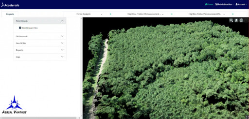
Accelerate focuses on the processing, storage, and transformation of aerial imagery from drones. Users in the Accelerate platform can define areas of interest, create projects, and upload imagery. Users can then transform the imagery into powerful Orthomosaics, Digital Surface Maps, and Point Clouds to support robust analysis and information extraction. The data in Accelerate is stored securely via Amazon AWS cloud computing services and is compatible with other cloud vendors based on customer needs. Accelerate is designed for all stakeholders and needs, from individuals affordably archiving and visualizing their data and running their businesses to enterprises collecting imagery at scale.
The first release of Accelerate is a stepping stone to addressing the growing data management challenges in the drone industry. Future releases will focus on adding and blending input data (e.g., satellite data, weather data) and embedding complex analytics algorithms to interpret and turn the data into valuable information with a wide range of applications.
"We are extremely pleased to have come this far in such a short time in the development of the Accelerate Platform," said Jarrod Lichty, VP of Product. "The challenge of data management and transformation in the drone space will continue to grow as drones proliferate. This first release of Accelerate is foundational for solving present and future challenges. Watch this space closely!"
Accelerate comes with an ever-growing list of drone data analytics capabilities to turn imagery into information. Aerial Vantage is committed to staying at the forefront of the latest drone data analytics trends and innovations for customers. The drone company's expertise in using artificial intelligence and machine learning enables the transformation of captured data into value for organizations, such as implementing a computer vision algorithm that consistently provides insights.
Ready to transform your aerial data usage? Accelerate is now live. Be among the first to accelerate data to valuable information and get ahead of the competition.
##
About Aerial Vantage
Aerial Vantage is a drone, software, and analytics company with a multi-faceted vision to lead the industry toward safe, efficient, and economically viable VLOS and BVLOS operations using advanced expertise in AI, ML and computer vision. Their mission is to automate and improve the business value from drone missions across a range of industries, enabling customers to better utilize aerial data to meet their goals.
Contact Information:
Tom Davis
Chief Operating Officer
tdavis@aerialvantage.us
650-248-1088
Press Release Service by Newswire.com
Original Source: Aerial Vantage Launches Accelerate, a Powerful Geospatial Intelligence Platform

