Agricultural businesses have shown great adaptability to various economic and environment-related challenges. Now is the era of high technologies that transform every aspect of life, including agriculture and how agri-companies do business. Significant tech advances of the past decade have disrupted traditional agricultural practices giving rise to digital smart farming or precision agriculture.
Armed with big ag data collected both from the ground (in-situ sensors, machinery) and above (drones, satellites), farmers get invaluable insights into the state of crops and fields. This information has become key to making better field management decisions and ultimately increasing crop productivity while improving environmental outcomes. Instead of time-consuming ground truthing, crop growers can now turn to geospatial data analytics to detect any possible threats to future yields from the comfort of their offices.
How EOS Data Analytics enables smart agriculture
The adoption of smart agriculture is propelled by governments and private companies marrying satellite imagery analysis technologies with agricultural customer needs. EOS Data Analytics (EOSDA) is one of them. This global provider of AI-enabled geospatial data analysis creates solutions that help businesses in agriculture, forestry, and 20 more industries to make quick and accurate data-driven decisions.
The company combines information extracted from spaceborne imagery with proprietary machine learning algorithms to analyze the state of vegetation (crops and trees) and enable sustainable, productivity-boosting practices worldwide.
Its main agriculture-focused product EOSDA Crop Monitoring is an online service for satellite monitoring of fields that gathers a wealth of crop-related data in one place and proves the importance of geospatial data analysis in agriculture.
The tool precisely identifies problem areas within the field where crops are hit by water/cold/heat stress, pests, or diseases, and enables timely response alongside more efficient scouting. The diverse functionality of EOSDA Crop Monitoring includes vegetation and productivity maps, satellite-derived vegetation indices calculation, access to current and historical weather data, crop rotation records, and much more to benefit all agriculture market players. As a result, farmers can perform variable rate application of inputs; insurance companies can measure field potential and validate insured events; while traders and machinery dealers can estimate the market size and predict demand in areas of interest.
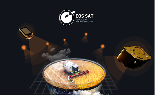
Launching the satellite constellation geared to agriculture
The most anticipated project of EOS Data Analytics is EOS SAT, the world’s first agriculture-focused satellite constellation among remote sensing tech companies.
The fleet will comprise seven small 178-kg satellites placed into low sun-synchronous Earth orbit and supplying high-resolution optical imagery (panchromatic – 1.4 m/pixel; multispectral – 2.8 m/pixel). The main purpose of EOS SAT project is the monitoring of croplands and forest areas and the collection of Earth observation data applicable in agriculture and forestry. Geospatial data analysis will reveal information about plant development and soil conditions within the cultivated areas, which can be further correlated with weather and crop/forest management data to produce more actionable insights. EOSDA will carry out all of these in-house, providing a full data cycle within 16 to 24 hours since image acquisition.
“By launching our own satellite imaging constellation, we aim to establish a full satellite data production vertical – from direct imagery collection to processing, analysis, and delivery,” says Rim Elijah, VP of Sales at EOS Data Analytics.
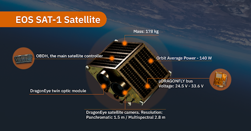
The first satellite within the constellation, EOS SAT-1, is set for launch in early 2023. By 2025, when all seven satellites will reach orbit, they are expected to monitor up to 9.4 square kilometers daily. The goal is to cover 100% of countries with the largest crop- and forestland territories, as well as 100% of cultivated lands in countries having the biggest agroforestry potential.
EOS SAT-1 will acquire panchromatic satellite images and multispectral ones consisting of 11 spectral bands. The spectral capabilities will expand with the launch of the next six satellites to 13 spectral bands, all of which have crucial applications in vegetation monitoring through geospatial data analytics. For instance, the shortwave infrared band (SWIR) having strong contrast can be used to sort agricultural produce and estimate crop or fruit maturity. It can also indicate the moisture content of crops, grains, and fruits, as well as highlight the extreme dryness, helping crop growers deal with issues on time and avoid major yield losses.
With its own reliable source of high-quality satellite imagery and near real-time geospatial data analysis, the company aims to close the existing data-related gaps and increase the adoption of smart farming among agribusinesses.
The future of satellite-driven agriculture
Agriculture is a major economic sector and the core pillar of global food security. As the world population keeps growing and is expected to hit 10 billion by 2057, agribusinesses should rethink the ways they operate to boost productivity and ensure sufficient food supply, while also managing to preserve natural resources and avoid environmental outcomes.
Satellite imagery and geospatial data analysis have a proven record of agricultural applications, including prediction of adverse weather conditions, soil moisture monitoring, planning the crop growth patterns and choosing the best dates for field activities, and determining the precise dosage of pesticides or fertilizers to name a few. In combination with machine learning algorithms, they can bring more benefits, including crop type mapping, field boundary detection, and yield prediction. The launch of EOS SAT fleet and constant supply of high-quality agri-related satellite data will enable multiple applications beneficial to businesses, the environment, and the world population.
Read more investing news on PressReach.com.Subscribe to the PressReach RSS feeds:- Featured News RSS feed
- Investing News RSS feed
- Daily Press Releases RSS feed
- Trading Tips RSS feed
- Investing Videos RSS feed
Follow PressReach on Twitter
Follow PressReach on TikTok
Follow PressReach on Instagram
Subscribe to us on Youtube