The expanded program is seven times larger than initial survey and aims to define the full extent of a 900-metre-deep system that widened at depth and remained open beyond previous survey limits
VANCOUVER, BC / ACCESS Newswire / February 20, 2026 / ESGold Corp. (CSE:ESAU)(OTCQB:ESAUF)(FSE:Z7D) ("ESGold" or the "Company") is pleased to announce the commencement of a second-phase Ambient Noise Tomography ("ANT") survey covering approximately 70 square kilometres (the "Program") at its Montauban Gold-Silver Project in Québec. The expanded ANT survey commenced on February 17, 2026, and the Program represents the most extensive geological investigation conducted across the Montauban property in its 110-year history.
This Program represents a seven-fold expansion of the Company's initial 10 km² ANT survey completed in 2025, which formed the basis of ESGold's integrated 3D geological model. That model imaged mineralized architecture extending to approximately 900 metres in depth and outlined at least two (2) kilometres of strike length indicated, with the corridor widening at depth and remaining open at the limits of the original survey coverage.
The expanded survey Program is designed to confirm whether this interpreted structural corridor continues along strike and to assess the potential for additional mineralized lenses within the broader framework. Results will be incorporated into the Company's geological model to refine high-priority step-out drill targets and guide a focused drill program planned for spring 2026, with the objective to systematically evaluate the broader district-scale volcanogenic massive sulphide (VMS) potential at Montauban.
CEO Commentary
"This next phase marks an important step in defining the full scale of Montauban," said Gordon Robb, Chief Executive Officer of ESGold. "Our initial ANT survey and integrated 3D model revealed a deep and expanding mineralized corridor extending to approximately 900 metres and over at least two kilometres of strike. Critically, the system widened at depth and remained open where the survey ended. The expanded 70 square kilometre program is seven times larger than our initial survey and represents the most comprehensive geophysical assessment ever conducted across the Montauban district. For the first time in the project's history, this land package has been consolidated under one operator and is being evaluated using modern, deep-penetrating geophysical tools. We believe we are at a pivotal stage in understanding the broader geological framework of Montauban."
Key Highlights of Survey and Program
Initial ANT survey identified mineralized architecture extending to approximately 900 metres in depth - significantly deeper than historical drilling, which was largely confined to shallow levels.
At least 2 kilometres of strike length defined within the initial 10 km² survey area.
Mineralized corridor widened at depth and remains open where truncated by survey boundaries.
New 70 km² ANT program expands coverage approximately seven times beyond the original survey footprint.
Largest district-wide geophysical survey ever conducted at Montauban.
First time in Montauban's history that a consolidated land package of this scale has been systematically evaluated under a single operator.
Survey results will guide targeted step-out drilling planned for 2026.
3D Geological Model
A video presentation of the integrated 3D geological model referenced in this press release can be viewed at the link below.
View Here: Video of 3D Model
Defining the True Extent of the System
The Company's initial ANT survey and integrated 3D model has most likely materially changed the geological understanding of Montauban. While historical mining operations extracted gold, silver, zinc, and lead from multiple shallow zones, drilling was largely confined to depths of approximately 50 metres, with the deepest historical holes reaching approximately 250 metres.
The 3D model, constructed through integration of ANT seismic velocity data, historical drilling, geological mapping, structural interpretation, and geochemistry, identified a coherent mineralized corridor extending to approximately 900 metres in depth. Within the 10 km² survey footprint, the system demonstrated at least two (2) kilometres of strike length and showed indications of thickening or widening at depth.
Because the initial survey area was limited in its extent, the modeled mineralized architecture was truncated at the survey boundaries. The new 70 km² Program is designed to determine whether the interpreted corridor continues along strike and to evaluate its broader district-scale potential.
The expanded ANT survey will deliver high-resolution, three-dimensional subsurface imaging across a significant portion of ESGold's newly consolidated Montauban land package. The initial survey covered only a small fraction of the broader property, meaning the majority of the district has never been systematically evaluated using modern deep-imaging technology.
Survey Program details are set out below:
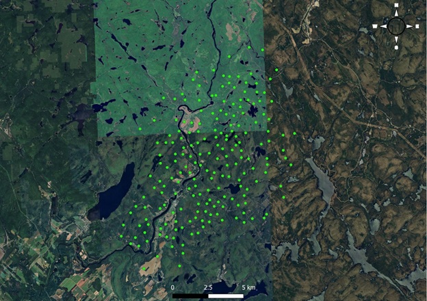
Survey Area: Covering 70 km² of Montauban's most prospective zones.
Strike Length: Mapping multiple kilometers along strike to identify mineralization extensions.
Depth Penetration: Scanning from 50 metres ("m") to 900 m deep, with potential for further extension.
Advanced Technology: Utilizing Caur Technologies' ultra-sensitive Geodes, which are 10x more effective than traditional geophones, combined with AI-driven modeling that integrates historical drill data and satellite-assisted geophysics.
-
Expected Impact of New Survey Program:
Expand the known deposit and enhance the potential for new discoveries.
Define high-priority drill targets for future exploration.
Assess the size, shape, and continuity of mineralized anomalies.
Integrate survey data into a state-of-the-art Predictability Model, leveraging all past regional and local exploration results.
Map of ESGold's Ambient Noise Tomography (ANT) Survey at Montauban
Advancing Exploration in Parallel with Production
The expanded ANT program is being conducted as ESGold continues to advance the Montauban Project toward near-term production in 2026. The Company's processing facility is fully permitted and construction-ready, with procurement of processing components underway.
Data from the expanded ANT survey will be integrated into an updated predictive 3D geological model and used to refine high-priority step-out drill targets planned for execution in 2026.
Game-Changing Technology: How ANT Works
Ambient Noise Tomography (ANT) leverages naturally occurring and human-made seismic vibrations. These signals travel through the earth and are recorded using ultra-sensitive Geodes. The data is then rapidly processed and transmitted, generating a high-resolution 3D model of the subsurface, with planned imaging depths of 400 m and beyond based on initial results.
This groundbreaking technology has already proven to be a game-changer in the mining sector, with the potential to redefine Montauban's geological model. By integrating AI-driven analysis with historical drill data, ESGold anticipates actionable insights that could unlock a major discovery.
Transforming ESGold's Exploration Strategy
The launch of this first-ever deep exploration program could be a defining moment for ESGold. By identifying new drill targets, mapping the full extent of mineralization, and uncovering previously hidden ore bodies, this survey Program could dramatically reshape the future of Montauban.
ESGold is taking a calculated approach, combining cutting-edge technology, systematic exploration, and near-term production. This strategy aims to create significant long-term shareholder value, flipping the traditional junior mining model by using cash flow from operations to fund meaningful discoveries while minimizing dilution.
Why This New Survey Program Matters to Investors
The initial 3D model demonstrated that Montauban extends significantly deeper and farther than historical exploration suggested. The identification of a 900-metre-deep system, widening at depth and open along strike, represents a material shift in the geological understanding of the Montauban project.
The new 70 km² ANT Program seeks to determine whether this mineralized corridor continues beyond the limits of the initial survey and whether Montauban represents a larger, structurally controlled district-scale system.
At the same time, ESGold is advancing toward production at a fully permitted facility. This dual-track approach - near-term cash flow alongside systematic district-scale exploration - positions the Company to translate geological progress into long-term value creation while maintaining strategic control over a consolidated land package.
Qualified Person Statement
The scientific and technical information contained in this news release has been reviewed and approved by André Gauthier, P. Geo., a Director of ESGold Corp. and a Qualified Person within the meaning of National Instrument 43-101 - Standards of Disclosure for Mineral Projects. Mr. Gauthier has reviewed the data underlying the ANT survey and the resulting 3D geological model and believes the interpretations presented are reasonable and appropriate for exploration targeting purposes. The interpretations and conclusions are conceptual in nature and are intended to guide further exploration; they do not constitute a mineral resource or reserve and are subject to confirmation through additional geophysical work and drilling.
About ESGold Corp.
ESGold Corp. (CSE:ESAU)(OTCQB:ESAUF)(FSE:Z7D) is a fully permitted, pre-production mining company advancing a scalable clean mining model across North and South America. The Company's flagship Montauban Gold-Silver Project in Quebec is under construction with production anticipated in 2026. With a dual-track strategy of cash flow today and discovery tomorrow, ESGold is building a platform for clean, sustainable growth and long-term shareholder value.
For more information, please contact ESGold Corp. at +1-888-370-1059 or visit esgold.com for additional resources, including a French version of this press release, past news releases, a 3D model of the Montauban processing plant, media interviews, and opinion-editorial pieces.
Stay connected by following us on X (formerly Twitter), LinkedIn, and joining our Telegram channel.
For further information please contact ir@esgold.com or 604-885-1348, or to connect directly, please reach out to Gordon Robb, CEO of ESGold Corp. at gordon@esgold.com or 250-217-2321.
On behalf of the Board of Directors
ESGold Corp.
Gordon Robb
Chief Executive Officer & Director
info@esgold.com
+1-888-370-1059
Forward Looking Statements
This news release contains "forward-looking information" within the meaning of applicable Canadian securities laws, including statements regarding the new survey Program, interpretation's of the existing program information, metallurgical recoveries, project economics, construction timelines, and exploration potential. Forward-looking information is based on reasonable assumptions believed to be current but involves known and unknown risks and uncertainties that may cause actual results to differ materially. Historical data referenced herein is not current, has not been independently verified by ESGold, and should not be relied upon for investment decisions. ESGold disclaims any obligation to update or revise forward-looking information except as required by law.
These forward-looking statements reflect the Company's current views with respect to future events and are necessarily based upon a number of assumptions that, while considered reasonable by the Company, are inherently subject to significant operational, business, economic and regulatory uncertainties and contingencies. These assumptions include, among other things: the ANT-based 3D geological model, its results and interpretation of the same, the newly staked land of the Company and the possibility for mineralization therein, the new proposed survey Program, conditions in general economic and financial markets; accuracy of assay results; geological interpretations from drilling results, timing and amount of capital expenditures; performance of available laboratory and other related services; future operating costs; the historical basis for current estimates of potential quantities and grades of target zones; the availability of skilled labour and no labour related disruptions at any of the Company's operations; no unplanned delays or interruptions in scheduled activities; all necessary permits, licenses and regulatory approvals for operations are received in a timely manner; the ability to secure and maintain title and ownership to properties and the surface rights necessary for operations; and the Company's ability to comply with environmental, health and safety laws. The foregoing list of assumptions is not exhaustive.
The Company cautions the reader that forward-looking statements involve known and unknown risks, uncertainties and other factors that may cause actual results and developments to differ materially from those expressed or implied by such forward-looking statements contained in this news release and the Company has made assumptions and estimates based on or related to many of these factors. Such factors include, without limitation: the timing and content of work programs; results of exploration activities and development of mineral properties; the interpretation and uncertainties of drilling results and other geological data; receipt, maintenance and security of permits and mineral property titles; environmental and other regulatory risks; project costs overruns or unanticipated costs and expenses; availability of funds; failure to delineate potential quantities and grades of the target zones based on historical data; general market and industry conditions; and those factors identified under the caption "Risks Factors" in the Company's continuous disclosure documents filed on SEDAR+ at www.sedarplus.com.
Forward-looking statements are based on the expectations and opinions of the Company's management on the date the statements are made. The assumptions used in the preparation of such statements, although considered reasonable at the time of preparation, may prove to be imprecise and, as such, readers are cautioned not to place undue reliance on these forward-looking statements, which speak only as of the date the statements were made. The Company undertakes no obligation to update or revise any forward-looking statements included in this news release if these beliefs, estimates and opinions or other circumstances should change, except as otherwise required by applicable law.
Neither the Canadian Securities Exchange nor its Regulation Services Provider accept responsibility for the adequacy or accuracy of this release.
SOURCE: ESGold Corp
View the original press release on ACCESS Newswire